
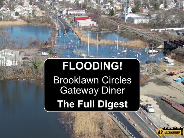

The Brooklawn Circles (New Jersey) have been plagued by flooding since the day they were created 100 years ago. But the flooding recently appears to have gotten worse and residents are growing frustrated by this, and in the minds of many it seems nothing is being done to address.
But there really are significant efforts underway to address the flooding… and some of those improvements could be in place this week!

This is a long article as it covers all facets of the flooding, the multiple efforts that are already underway to address aspects of the flooding problem, as well as potential future solutions. Plus to this point, I haven’t really covered the Route 47 bridge rebuild… which is intended to also solve the Rt 47 “Gateway Diner” flooding.
And the big surprise bonus… it seems that the more recent extended flooding events we’ve been experiencing at the circles may be due to a correctable problem with the drainage systems. NJDOT has some plans in the works, which could come as soon this week!
And only 42Freeway is bringing you all of this information and in one article. It’s a long one, but consider this the Farmer’s Almanac of Brooklawn Circle Flooding.

Brooklawn Circles – Background
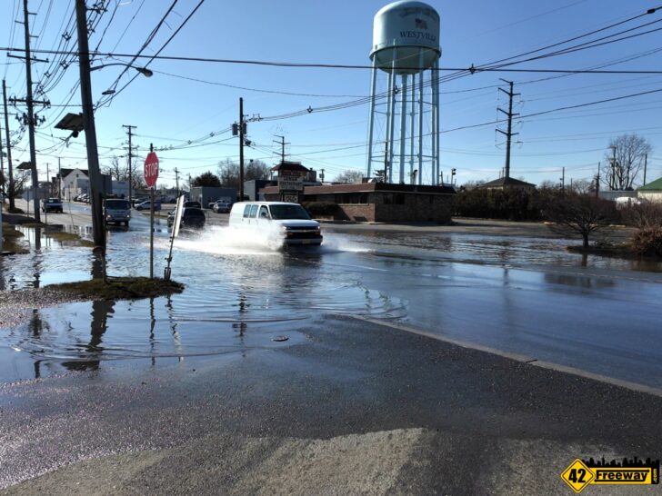
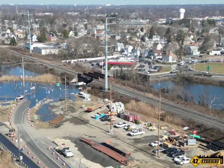
If you’re unfamiliar with the Brooklawn New Jersey circles, they are two traffic circles positioned together like the number 8. The West circle sits very close to the Delaware River which is a tidal waterway connected to the Atlantic Ocean. The combination of rain and high tides frequently floods the west circle down to the center connection point between the two circles.
The “interchange” of the circle connects several highly traveled roads including NJ State Highways Rt 130, 47 and 45… as well as key local roads.
Simply, when the circles flood it literally shuts down commuter traffic for not just the immediate area.. but also can impact and back up traffic for miles.. including into the Federal Highways of I-76 and 295.

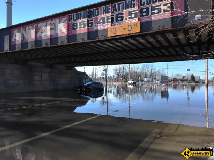
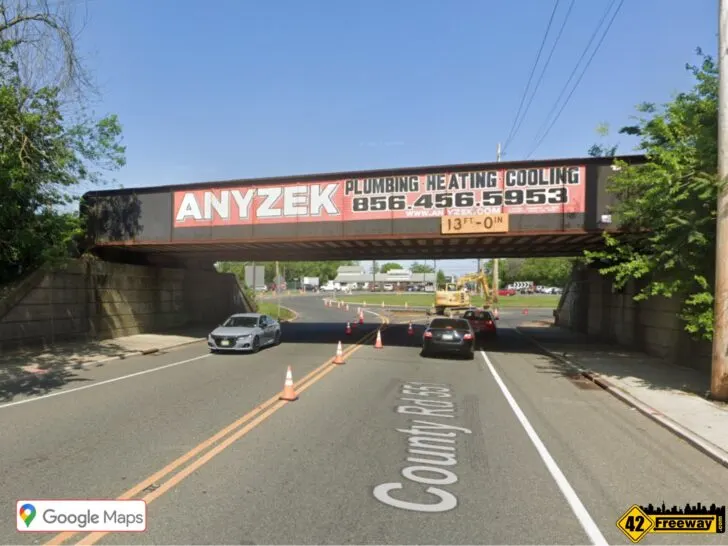
Another key aspect to the flooding challenge is a train bridge overpass goes through the center connecting point of the two circles.
The train tracks and bridge are set at a height to give trucks passing underneath enough clearance, which makes the road below it the lowest point. This key roadway segment is where cars are frequently stranded in the flooded waters, as the lower roadway can make it’s depth deceiving.
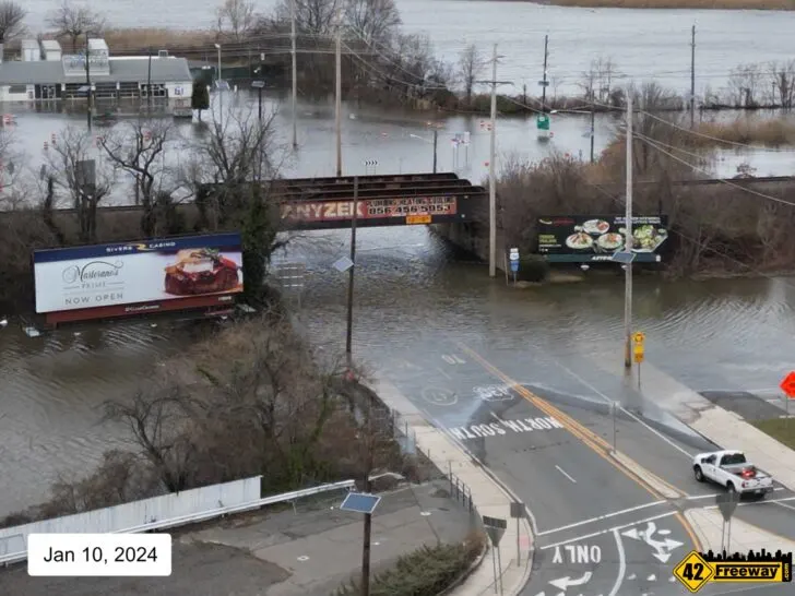
There is another adjacent flooding area which is typically grouped in with the Brooklawn Circles discussions. In Westville just across the Big Timber Creek over the Route 47 Bridge, the roadway at the base of the bridge (in front of the Gateway Diner) drops significantly, and typically floods as the tidal waters are higher than the roadway.

While the flooding has been a challenge for as long as all of us been alive, it’s become clear to everyone that the recent weeks and months of flooding events have become particularly worse.
Recently, significant amounts of rain have put additional moisture into the waterways and ground which seems to enhance the flooding impacts.
And for the past few days, you can add in a “Supermoon” impact. A Supermoon is when the moon is at it’s closest point to the earth, which increases it’s gravitational pull on the earth… and actually raises the tides hider!
This is likely a major contributor to why over the last few days even during completely bright sunshine and no rain for many days… the Brooklawn Circles and Rt 47/Gateway Diner area have still experienced significant flooding events!

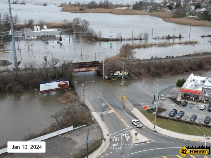
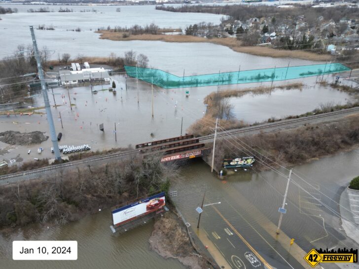
Another interesting aspect is officials have noticed a change in the flooding behaviors recently at the circles. The water under the train bridge is staying around long after the tides have receded. Many hours in fact… when the existing drainage systems is place should be moving the water out as the tide goes down. This is something that may have a more immediate solution!
So as mentioned this has become a growing frustration for commuters and residents as it seems the problems have increased, and residents aren’t clear on if anything is being done to address the problems.
The reality is, there are already several efforts which have started, which should provide significant improvements to the flooding events.
Two adjacent large bridge rebuild projects in the immediate area both include significant aspects to address flooding. Also a potential deficiency in the existing drains under the train bridge may have been identified with a potential quick solution on its way… and yes there is even talk of building a barrier wall to keep the water from coming in at all!
The best part about this is most of these efforts are active projects right now!
This information has been compiled from existing NJDOT documents and project knowledge, as well as third-party sources familiar with the project.
Where Does The Water Come From?
I spent 45 years of my life living in Bellmawr literally blocks away from the Brooklawn circles and I am very well aware of the long term flooding issue and the impacts on the commuters and residents!
But honestly I feel like we always connected the flooding with the rain. Every time a big storm was predicted, we would all wonder if the circles were flooded. And absolutely rain is a big factor!
But the real flooding event seems to come from the tides. Extra high tides which can be exacerbated by extended rain or supermoons.
For example, I visited the site on Friday at high tide and it was a bright sunny and day hadn’t rained for several days.

That being said the circles were impacted by significant flooding!
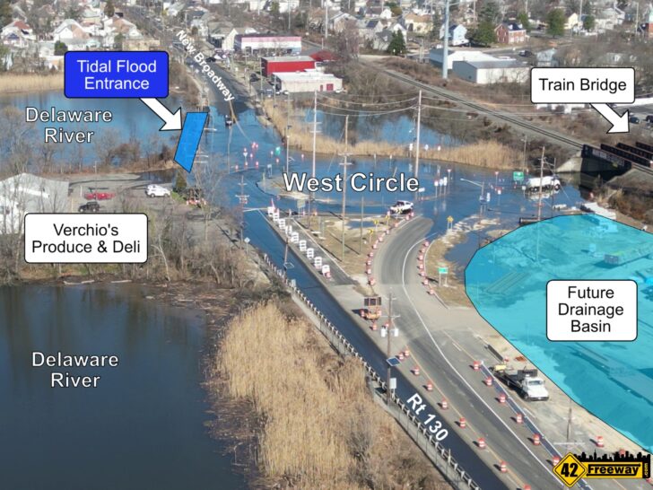
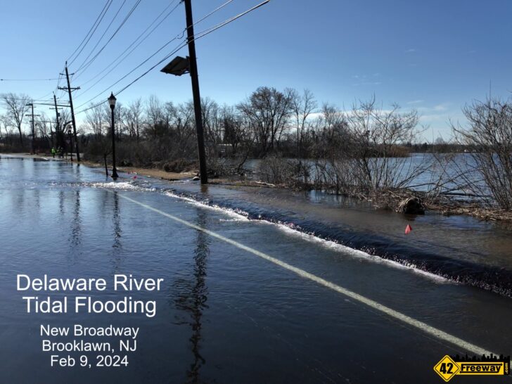
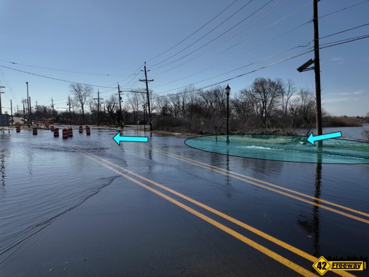
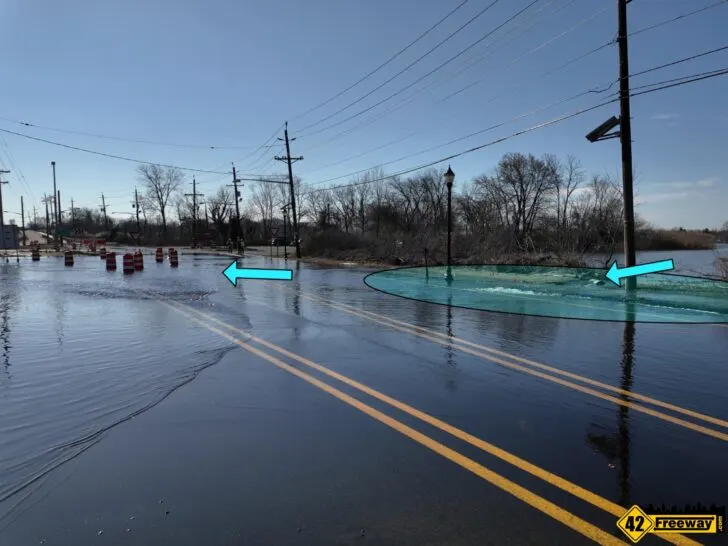
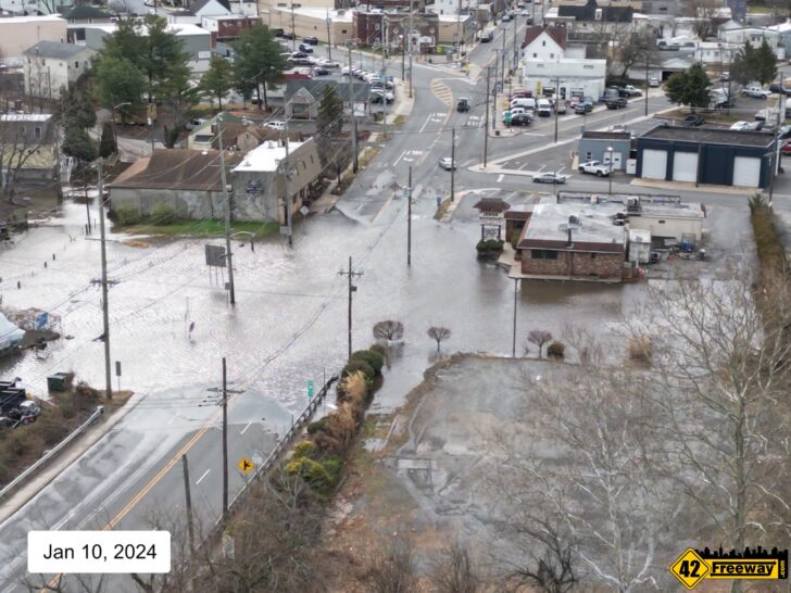
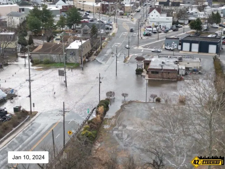
It seems that the core source of the flood waters comes from the Delaware River, where at the highest tides the river rises higher than the New Broadway sidewalk! (Between Verchio’s and Ray-Bets)
Friday afternoon in the bright sunshine (Feb 9th), it was an amazing opportunity to see that the water was just pouring over the sidewalk into the roadway and down to the circles! It was like a little waterfall…even with rapids.
As mentioned the roadway underneath the train bridge is the low point so the water slowly moves across the circle and then starts building up underneath the train bridge.
And when the existing drainage systems are fully functioning, as the tide goes down the water collected in the circles and under the train bridge should drain almost as fast as the tide goes down.
Quick Improvements? Recent Extended Flood Events
It’s important to note there are two aspects of a flood event.
Logically, we typically focus on the fact that the water is coming in to a place that it should not be. The Flood.
A second aspect though that we usually don’t have to be concerned with is… How fast does the water move back out?
A common flooding pattern is “something floods, the source of the water goes away, and the flooding goes away”. Which in the case of tidal flooding would mean that if an area floods because the tide is too high, we would expect that when the tide goes back down… the flooding goes away.
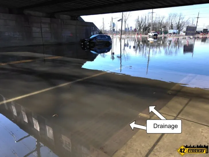
But it seems that in the case of the Brooklawn Circles… particularly the important roadway underneath the train bridge… the water is coming in, but it does not go away. For many hours!
Officials have been on-site and noted that after a tide related flood event occurs, hours later they are standing next to an impassable flooded Brooklawn Circles roadway, when all of the natural bodies of water surrounding (Delaware River and Big Timber Creek) have all gone down significantly!
So what starts to get very interesting is there is already a very effective, yet simple drainage solution in place on that roadway!
At least 8 drains and likely many more are in position in the very immediate area around the bridge overpass. Those drains have direct underground piping to the adjacent waterways.
So, the simple engineering logic here is when the tide around the Brooklawn Circles goes back down, the water under the train bridge should also go down.


Which brings us back to the two aspects of a flood event. In this scenario we’re not really focused on stopping the tidal flooding from happening, but officials have noticed that more recently the water is not leaving the roadway as fast as it should… which greatly increased the impact to commuters, residents and businesses.
I’ve been told by sources that NJDOT officials have been on site through at least last week analyzing the extended flooding, and have recognized that something is not working the way it should with these drains.
Mostly from initial theory, it would seem that somewhere within the underground piping there is a clog.
To address this, what I’ve been told (unofficially) is that this coming week (as early as Monday) a team from NJDOT and contractors will be on site to further analyze if it could be a clogged drain problem, and determine if there’s something they can do immediately to unclog it if it does exist. High pressure water to force out a clog, maybe?
But to “cover all the bases” they are also bringing with them a temporary large pump.

Hopefully there is a path to quickly unclog the drains (assuming that is the issue), but if not… the pump will be set up in a way that it will be able to pump out the flooded circles soon after the tide recedes!
People familiar with the plan have stated that they have fairly good confidence that either they can unclog the drains, or if not the pump will be very effective at removing the water.
As soon as early this week we could see actual improvements to the Brooklawn Circle flooding… to the extent that the water will be removed out much faster than it has been these last few weeks.
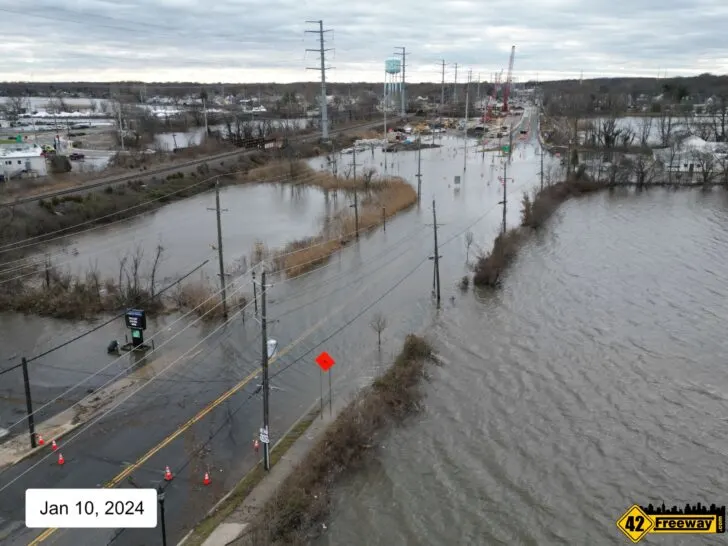
So with all that being said there is also another large water drainage project already underway in the area, which is targeted at also quickly draining the water out of the Brooklawn Circles interchange!
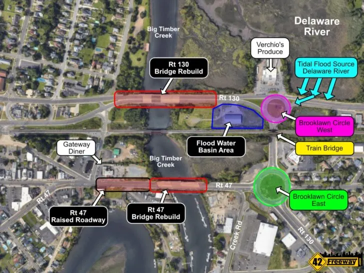
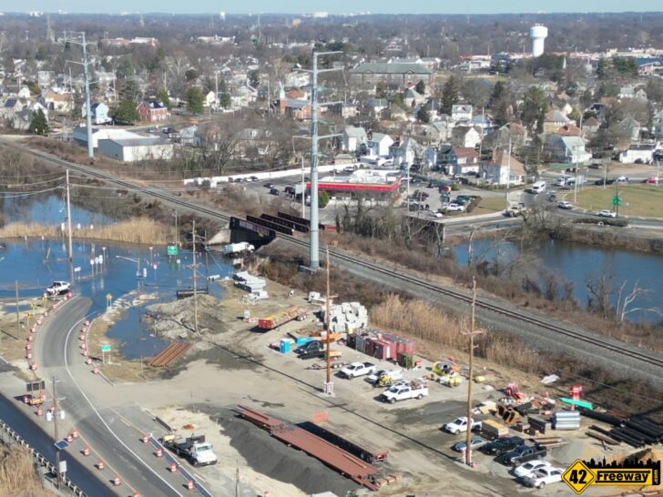
New Drainage Basin – Rt 130 Bridge Over Big Timber Creek
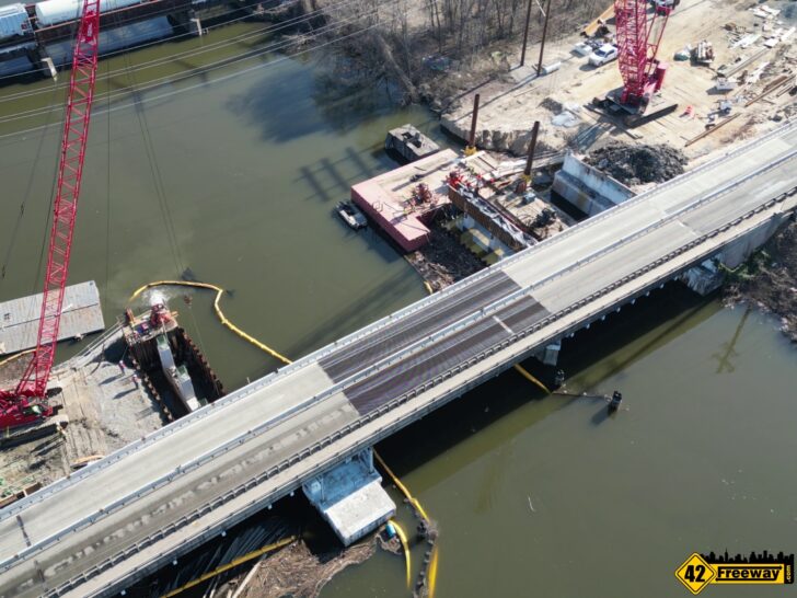
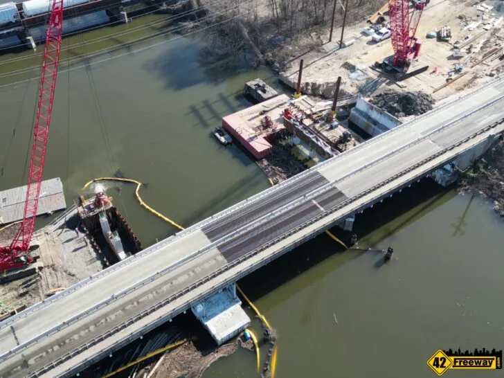
Heading off the West Brooklawn Circle towards Westville (and Rt 295), the Route 130 Bridge Over the Big Timber Creek is undergoing a full rebuild right now.
42Freeway wrote about this project in May of 2023 just as the lane reductions were starting ahead of construction.
Currently the four lane bridge has been split in half lengthwise, with traffic from both directions sharing two lanes as the construction team rebuilds the other half of the bridge.
This is a multiple year project with 10 different phases to it!
Another important aspect to the project is it will include a large drainage basin targeted at moving water from out of the area of the west Brooklawn Circle and the approach to the rebuilt bridge.
Currently there is a large piece of land between the West circle and the Big Timber Creek which is being used as a construction staging area for the bridge project: construction vehicles, materials, dirt /sand and more.
As the bridge project starts winding down in a few years, a significant portion of this land closest to the circles will see the development of a large manmade water basin.

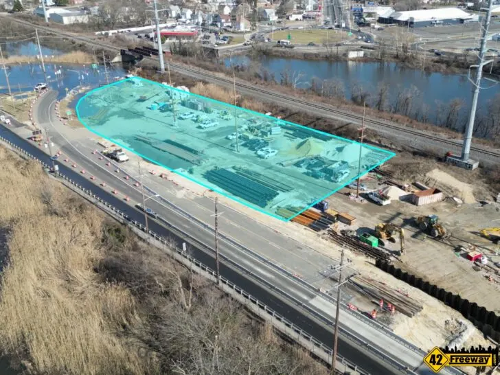
Connecting to the basin will be a series of roadway drains around the West Brooklawn Circle, in front of the Verchio’s Produce and Deli stand (which sits on the Delaware River side) and the roadway up to the new bridge.
Those new drains will be connected via underground piping into the new water basin… with the intent of moving rain and flood waters off of the roadways and circle!
So as described in the prior section, this effort is not intended to stop the title floods from coming in… but it is expected to move the water off the roadway faster when the tides go down.
Obviously tides and the floods can be at different heights, so there is some expectation that smaller flooding events could be minimized as the capacity of the basin could potentially keep the water at a manageable level.
But it seems the real benefit would be that when the flood does recede from the circle, the water that would normally stay under the west circle and under the bridge would have another place to drain out to.
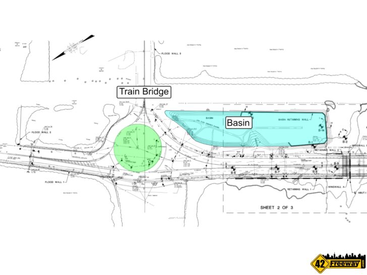

One thing I’m not certain about at this time is if this basin will have a one way “tidal flex check valve” outlet back out to the adjacent waterway. The thought being that once the tide goes back down, the basin could then drain itself out into the Big Timber Creek or Delaware River. I have seen the blueprint for the project, and while I do see the new inbound drainage grates and piping heading into the basin, i don’t see anything heading back out… but to be clear while I am a smart guy I not 100% privy to the full project scope!
So to tie this back to the extended flooding events we’re experiencing now underneath the train bridge… ideally if there is a clog in the existing drainage system it can be resolved quickly. But if that effort will take some time, there will be a pump temporarily on site to remove collected floodwaters. And the longer term additional roadway drainage inlets feeding a new water basin are coming.
Route 47 “Gateway Diner” Flooding – Raised Roadway.
Coming off of the Eastern Brooklawn Circles is another bridge over the Big Timber Creek, heading into the Westville (Route 47).
This bridge is also slated to be completely rebuilt and while the timing isn’t 100% set… Yes, both of these bridges coming off of the two circles and into Westville at some point will be under construction at the same time!
On the Westville side of the bridge, at it’s base in front of the Gateway Diner, the roadway drops significantly lower… lower than high tide! This causes frequent flooding events at the bridge base which can become even more challenging as cars coming over the top of the bridge may not see the flooding problem ahead of them immediately.

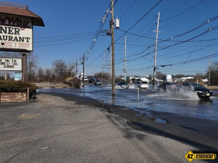
Typically the circles and the “Gateway Diner” area flood at the same time… which can really cripple commuters and create a safety risk for emergency vehicles.
For the Gateway Diner road flooding, the floodwaters comes from the Big Timber Creek (which connects to the Delaware) and the waters floods in from multiple directions including the Marina on the other side of the roadway from the diner.
The contract has already been awarded for this bridge project, and the Gateway Diner which sits at the base of the Westville side of the bridge has already been closed. The diner property will be utilized as part of the project’s water drainage sytem.
Sadly, as part of this project the Gateway Diner will be demolished… and something that I don’t think many folks are aware of, the building directly across Route 47 from the diner, will also be demolished.
So while the main goal of this project is to rebuild the aging bridge structure, it includes 2 aspects to improve the flooding at this roadway.
And honestly, I feel like this solution is going to 100% fix the “R47 – Gateway Diner” flooding!
The first core aspect is the roadway drop at the base of the bridge roadway will be removed… they will be raising the roadway in this area.
Significantly.
I have seen the project plans for this effort also, and in reviewing the elevations of the roadway it appears that at the current lowest point the roadway will be raised SIX feet!
Simply for the new bridge, the approach on the Westville side will be a much more level (gradual slope) grade than the current “dip down and back up roller coaster” roadway that we have now.
This of course is intended to raise the roadway here much higher than existing flood conditions.
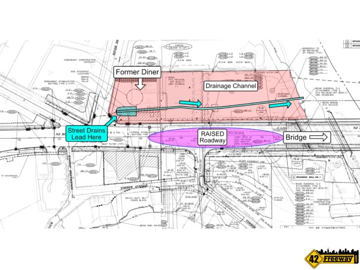

The second drainage aspect is that a significant number of new drainage inlets will be installed in that area, up to the start of Crown Point Rd. Those inlets will be channeled to a new collection area on the former Gateway Diner property, and a channel will be created to then direct that water back down to the Big Timber Creek.
I had a chance to speak (unofficially) to some of the contractors involved with the project and they said the first piece to happen is the demolition of the Gateway D\iner and the office building across the street… it seems they are waiting on the utility companies to remove power lines, and once that happens things may start moving fast!
Why Don’t They?
I haven’t mentioned this yet, but I run a Facebook group called “Is The Brooklawn Circle Flooded” where the only things we can discuss are questions about; is the circle flooded, and people giving statuses if the circle flooded! (Facebook Link)
Would you believe that group is approaching 9,000 members! And it’s incredibly active!
And at times we do have commentary about how people think the flooding at the circles should be fixed. Which leads to two key suggestion…
Raise The Roadway
The most prevalent solution suggested is to simply raise higher the roadway at the circles and where it travels under the train bridge.
But simply the challenge with that is, the train bridge goes between the two circles, and the roadway needs to be kept low enough to allow the safe passage of vehicles… particularly tall trucks which travel through.
If they raise the roadway, they have to raise the train bridge!

Now this is me just thinking about the problem… But it seems to be a much larger problem than most people are considering.
While trains are incredibly powerful, they are long and pull a massive amount of weight… and to be able to move successfully they have to operate on mostly flat tracks with very slight inclines.
If the grade goes too steep the trains are going to have challenges going up.
I mentioned this because if the train bridge were to be raised, it can’t be done like a bridge for a car with steeper inclines… which means to raise the bridge but maintain a gradual incline, a significant amount of train track on either side of the bridge would have to be raised!
Then you have to start considering what else would have to be impacted by raising the tracks for a long distance? An additional bridge over in Gloucester City? Crossings in Westville?

The project quickly becomes bigger.
The second challenge is, there is only one train track on the wider bridge, and it is used every single day to move large quantities of very important materials.
So if we’re rebuilding a bridge for passenger cars it’s very easy for cars to navigate over to the side or take another path… But with rebuilding of a train bridge, it seems it would be much more challenging to rebuild a new higher bridge while still maintaining the existing train line so that deliveries could continue to be made each day.
And obviously those materials are very important to the businesses, so it’s unlikely to say to that the train was going to stop for two years while a bridge and train tracks are rebuilt!
So my observations on the problem is, it just seems like a much bigger and more expensive proposition to raise the roadway and the train bridge.
Why Don’t they Build a Wall?
Another idea that is brought up regularly is “Why don’t they build a wall to hold back the river?”
And while some may look at that and think it’s a crazy idea… Guess what, it’s being seriously considered.
Back in 2022 Camden County held a public information session where the flooding in the area of New Broadway (coming off the West circle towards Ray-Bets) was the topic… and several ideas were presented, including building a barrier to hold back the Delaware River! (YouTube Video)
To clarify, this is the exact area where the water comes in from!
This was public session was presented as an early stage list of ideas including adding one-way check valves to existing drainage pipe outlets.
But third on the list was the idea of building an earthen berm to hold back the river!

It was also called out that it really needed to be engineered and studied so that additional problems aren’t created. Water will always find it’s way, so you don’t want to hold back the river in one area only to see it pop out somewhere else, creating new impacts!
Now you may be wondering why Camden County was holding this session? That is because this portion of the roadway is not owned/operated by the State of New Jersey. Every other aspect of what I’ve written about so far has been State roadways, except for this one leg of road which heads towards Gloucester City.
That being said it was stated in the public session that any project which would happen here to solve this issue, would be Federally funded. I would also expect that NJDOT would likely be a part of the project as they see it as a subset of the larger circle flooding issues. It’s all a connected roadway ecosystem.

As I was watching the public. presentation. I thought this is a great idea, but it just seemed way off in the future.
Well one of my sources gave me a very unofficial statement saying that the idea of building a barrier wall to hold back the Delaware River is getting significant consideration through all of the related Government Agencies.
While there’s nothing officially put out, and definitely no timelines.. but I am hopeful. Maybe there was a reason they chose now to have that public information session!?
That being said I am also very well aware that it’s currently a narrow strip of land from the roadway to the river. We’re talking about wetlands and the Delaware River… and it seems anything that has potential environmental impacts just has a very large and long analysis aspect to it!