

Last weekend was the 6 month anniversary of the Direct Connection roadway collapse in Bellmawr. Very simply… In a mid-September letter to the 5th District Legislative Team, while NJDOT provides key contributing factors to the collapse, they are still working on the definitive solid answers on; the cause, who is at fault, the planned solution, costs, timeline… or who-pays for it.
The recent round of information was driven by inquiries of the Fifth District Legislative team to NJDOT, driven by Bellmawr’s own… Assemblyman Bill Moen.
Read on for more details of what NJDOT provided.
This post is mostly written words… not a lot of photos!\
UPDATE: I updated this post soon after putting online, to clarify further the embankment support columns, which it seems do not extend into the raised wall and roadway area.
Six Months and Looking for Answers
42Freeway realized it was approaching the 6 month anniversary of the collapse and reached out to both Assemblyman Bill Moen of the Fifth District Legislative team, and to NJDOT Communications Director for any updates.
We first caught up with Moen who shared with 42Freeway their Sept 10th letter his team sent to the NJDOT Commissioner asking for an update on the project.
While the letter thanks NJDOT for sharing information “as it becomes available”, and notes they had met in August… the 5th District team was looking for additional details driven by recent more extreme weather (and presumably the upcoming winter weather)
With the recent extreme weather that has come through our area, there is a growing concern with our constituents about the safety of the construction site as well as the stability of the new wall once construction is complete. Our constituents would like assurances that both the construction site and the completed wall can withstand an extreme weather than may pass through the area, as it seems to be a more common occurrence
Fifth District Legislative Team Letter to NJDOT Commissioner Gutierriez-Scaccetti Sept 10, 2021
As mentioned, the Fifth District letter to NJDOT does state that they had a formal meeting a month prior
During our last meeting on August 10, 2021, you and your team indicated that forensic investigations were still ongoing, which included a forensic excavation, soil samples and testing of grout piles.
Fifth District Legislative Team Letter to NJDOT Commissioner Gutierriez-Scaccetti Sept 10, 2021
NJDOT Response and Update
Days later (last Friday) we heard from the NJDOT who provided 42Freeway with their response letter to the 5th District team, which was sent recently. (Note: Assemblyman Moen has shared this information to his Facebook page this morning)
The response from the NJDOT commissioner Gutierriez-Scaccetti is 6 paragraphs long, with the first two giving background on the project.
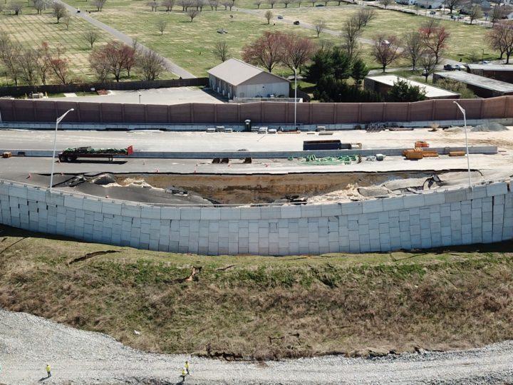
Specific to the collapsed wall (Wall 22), she offers this information
As a matter of background, Wall 22 is supported on a slope which is approximately 30 feet high. The slope was constructed using embankment fill material. Available subsurface data from the time of design dictated implementation of a ground improvement technique involving a Column Supported Embankment System (CSES)
NJDOT Response on Direct Connection Collapse, Sept 15, 2021
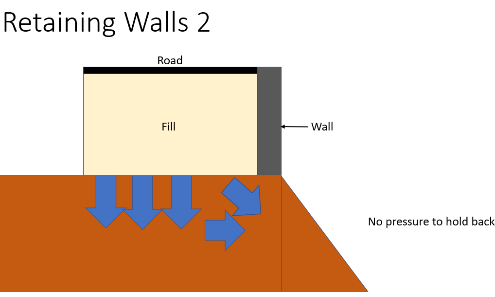
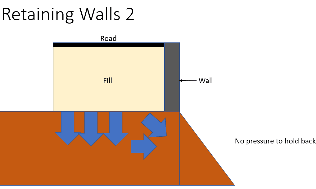
The man-made embankment was a key part of my analysis video from the spring.. that it did not have the backing pressure to support the weight of the raised wall and large amount of backfill (as compared to if the wall were developed on a flat piece of ground)
Support Columns?
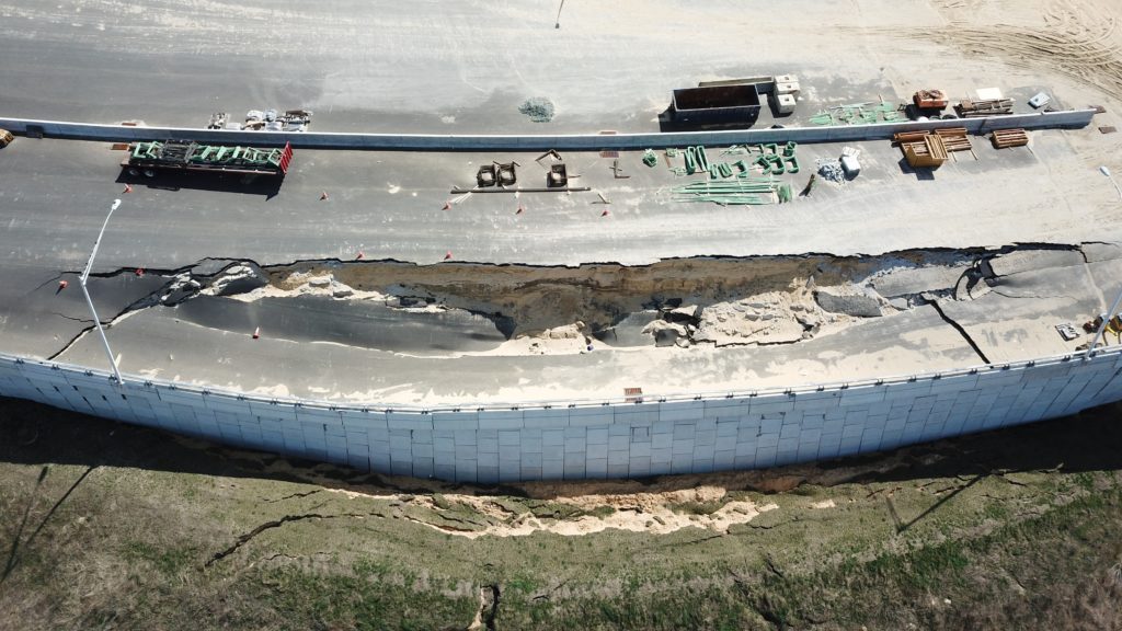
And while the NJDOT response calls out that a column based support system was used… when we look at the collapsed portion of the project wall after the collapse and again today, it seems the columns within the Wall 22 area (where the collapse was) do not extend up to the roadway.
Actually reading on through the NJDOT letter we can infer that the columns only were for the embankment level, and NJDOT goes on to say “affecting the embankment material and CSES” which sounds like the support columns themselves moved?
Also, I would think that the support columns should extend to the roadway? Seems they were just to the top of the embankment level and meant to build a solid foundation for the raised the roadway fill area above, which doesn’t have columns extending into it?
In the image below, taken soon after the collapse (Provided by Mike Kruce Photography) we can see how the roadway split as the wall pushed out and down… One would think the support columns below the surface would be deep enough that they would’ve stayed in place?
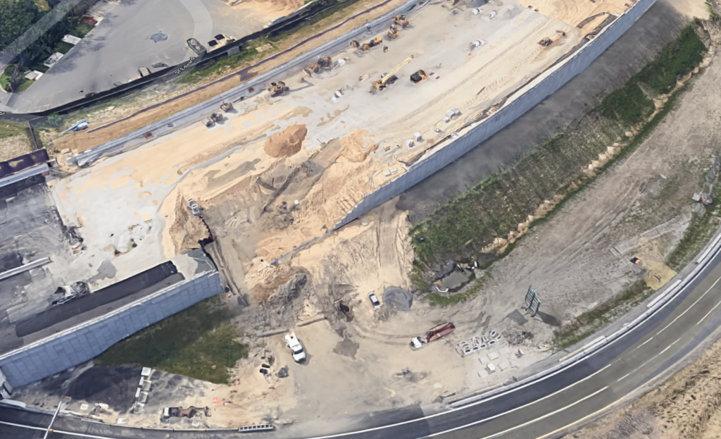
And while I unfortunately do not have an updated drone photo… the NJDOT contractors have removed significantly more of the roadway going back (presumably to secure the site) and at least from a visible drive by inspection, I see there are no visible columns in the roadway fill area going back further. So yes it seems the columns are under the ground level, and not the roadway

Interestingly, Google Maps Satellite view had captured this area of the roadway when it was under construction! This shot shows an access area on the left side of the collapse area, before being completed. There aren’t any visible columns along the wall edge.

Well we are asking NJDOT for additional details on the specifics of the columns and where they are located.
Ideally a graphic depictions would be nice .
Moving on, NJDOT writes about stabilizing the site to alleviate additional concerns of collapse, and the ongoing investigation:
Immediately after the partial wall collapse, the NJDOT took measures to temporarily stabilize the site and retained Hardesty & Hanover to conduct an independent forensic investigation. An engineering monitoring program was implemented, including continuous survey monitoring and geotechnical instrumentation to assess the existing and future site conditions. The independent technical forensic investigation by H&H of the design, as built information of Wall 22, site history and subsurface conditions is ongoing.
NJDOT Response on Direct Connection Collapse, Sept 15, 2021
What NJDOT Knows and Provides
Based on the ongoing investigation, it appears that Wall 22’s partial collapse involved both vertical and lateral displacements of the embankment fill materials and showed that the partial collapse extended through the Column Supported Embankment System (CSES). The following are potential contributing factors that led to the partial collapse.
NJDOT Response on the Direct Connection Collapse
Here is what we see as core factor one, which was called out by several 42Freeway readers last spring on our Facebook page. Seems the local town residents knew about the wet conditions there long before the collapse!
The project site has a high groundwater condition and heavy precipitation, observed on March 24, 2021, appears to have exacerbated this condition, affecting the embankment material and CSES. The high ground water condition appears to have compromised the subsurface soil conditions.
NJDOT Response, and what is described as one of the core reasons for the collapse
Affecting the embankment material and CSES
In my analysis video from the spring, while I don’t go into ground water conditions.. I do call out (and depict) that it appeared the large embankment leading up to the wall did not have enough natural resistance to support the elevated wall and roadway.
If the wall were developed on a fully flat piece of ground, the soil underneath (the embankment in this case) would not have been able to slide out as it did.
I feel that NJDOT is saying… 42Freeway you weren’t wrong.
But yes, the ground water in the area was a huge, if not largest… driver for the collapse. Softening the embankment and subsoils, and adding additional weight and pressure to the surface.
I factor in my earlier theory is the fact that there weren’t any visible columns in the large exposed area. It had been theorized to me unofficially that the project was using a layered sand approach.
As mentioned, I am reaching out to NJDOT again to ask for more details on the CSES columns.
In Conclusion
The NJDOT Commissioner closes the response letter with a summary
In conclusion, heavy precipitation observed on March 24, 2021, the embankment fill material, subsurface conditions, and the high groundwater condition appear to have contributed to the partial wall collapse of Wall 22. Until the investigation has been completed and the forensic report has been finalized, definitive cause(s) of the partial wall collapse cannot be ascertained.
NJDOT Response, and what is described as one of the core reasons for the collapse
Adding my own interpretation to the NJDOT Conclusion:
- heavy precipitation observed on March 24, 2021: There was a lot of rain in the days leading up to the collapse
- embankment fill material: “lateral displacements” of the man-made embankment/fill-material enabled the soil under the wall to slide out and under from the wall.
- subsurface conditions: “high ground water condition appears to have compromised the subsurface soil conditions”, although there isn’t a lot of details on this in the NJDOT response.
- high groundwater conditions: related to the subsurface conditions, the project design and constructed needed to properly account for site groundwater conditions.
So according to the NJDOT, the project area is currently stable, and will safely handle additional extreme weather.
It appears that as part of the stabilization, they removed a large portion of soil that was at risk of additional slides, and capped it with asphalt to hold the remaining fill in place, and reduce soil runoff.
42Freeway will be asking for clarity on the CSEs columns
And we still wait for answers.
Later this week I’ll have a photo post update on the related Missing Moves project.
For all of the 42Freeway posts on the Bellmawr area road projects, click this link for a filtered view of all the posts.