

This Direct Connection Explainer article and video, describes what 42Freeway.com sees as the key reasons for the large and complex project in Bellmawr.
The associated video also presents all 12 of the distinct traffic movements and construction needed to complete them. It’s a higher level “this is how you’ll get from Point A to Point B” commentary.
Honestly this article only covers a small portion of the 35 minute video yet it turned out to be a a long read. May be faster to just watch the video! Link at the bottom.
I tried to create the video content in a way that it will be valid for several years, to help answer questions of people who just don’t understand the “whys” and “hows”
The big unanswered question is.. “when?”.
As we all know there was a wall and road collapse 18 months ago in one segment of the raised roadway. While NJDOT has released findings as to why it collapsed, they have not given any official details on what is being done to correct the collapse and rebuild it.. as well as new timelines.
So that’s about all you’re going to get on the collapse in this article and video. Sorry!
Did you know there is still a second tunnel utilizing a pump station to come.. check the video!
The 35 minute video is linked at the bottom of this article.
Direct Connection Bellmawr
The Direct Connection project is a $900+ Million Dollar project centered in Bellmawr New Jersey which intends to streamline roadway travel in this high traffic and confusing roadway area where Routes 295, 76 and 42 converge.
42Freeway has significant coverage of the project. For more details on all my road project coverage including Direct Connection click here.
My Top Three Reasons for Direct Connection
Below are my three key reasons for the Direct Connection and Missing Moves projects in Bellmawr.
Reality is they are all based on the same core reason.
The Federal Highway System wants high volume, high speed roads… preferably achieved with clearly defined distinct roadway paths for each traffic movement. As straight and direct as possible.
Design elements which result in slow traffic volumes and movement and are unsatisfactory:
- Tight curves: Traffic must slow down to navigate
- Commingled road movements: Without distinct routes, traffic slows as drivers consider their next move, and weave in and out of other vehicle paths.
- Missing routes: Not having all possible highway intersection routes accounted for, causes traffic to exit the highways for local roads.
And in the case of Routes 295/76/42 in the Bellmawr area of New Jersey, they suffer from all three of those above negative bullets.
That being said, let’s highlight three facets in the Direct Connection universe:
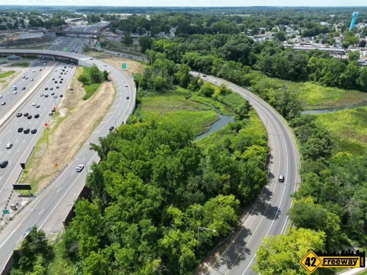
Al-Jo’s Curve
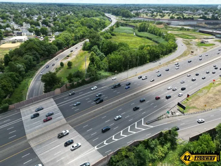
Heading down 295 South from say the Cherry Hill area, the roadway is typically a straight path and has a speed limit of 65 mph.
Until you reach the Bellmawr area where “Al-Jo’s Curve” is located. The roadway curves with a very sharp bend requiring cars to slow down to a speed limit of only 35mph.
“Sharp bend” is not actually strong enough of a word for the turn. It’s a peninsula-like protrusion.
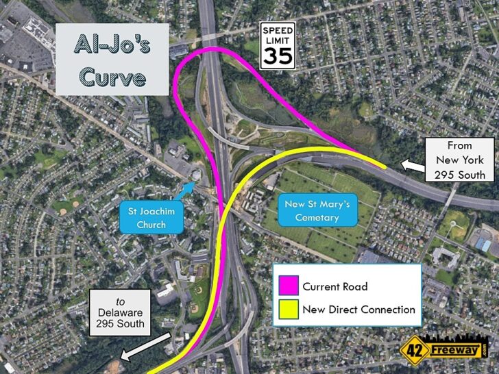
The overhead profile shows it as an almost 180 degree turn that looks very similar to the side profile of Great Adventure’s Kingda Ka rollercoaster.
A perfect design for a thrill ride. But highway designers prefer their roadways to be a lot less thrilling.
To add to the fun, the approach to the sharp curve is on a decline. It’s almost like the original designers were diabolically thinking “What else can we throw at them!? Bwwwaaaaa-haaaa-haaa!!”
The dangers of current roadway design should be very apparent just from traveling it or reading a description!
Accidents and Tipping Trucks
Another level of problem that has plagued the roadway since it was developed is how cars and particularly trucks navigate the turn.
Or more so how very occasionally trucks haven’t slowed down enough ahead of navigating the turn, and end up on their side blocking the roadway.

Imagine a commuter who is not as familiar with the area, cruising down 295 South at the legal 65mph speed limit
And then they approach Bellmawr and are not expecting the speed limit to drop to 35. “hmm really? That can’t be right?” Well that’s if they even notice the speed limit signs change!
Some are not expecting the road to curve as sharp as it does.
So the driver enters into the turn a little too fast, and in the case of a truck or tractor trailer they can have skids of stacked merchandise on the truck.
Once those pallets of merchandise start shifting and tipping, it can bring an entire truck over on to its side or worse!

And when that happens, typically the entire southbound lane of the roadway is closed. Traffic is impacted for miles!
I will add that it seems to me these situations used to be more prevalent 20 years ago, and I wonder if modern GPS systems in cars and trucks have helped reduce the problem.
Today commuters and truckers unfamiliar with the road get a better understanding of the crazy bend they are about to approach from their GPS systems and apps, and slow down accordingly. In 1985 drivers were a lot less aware of what was coming!
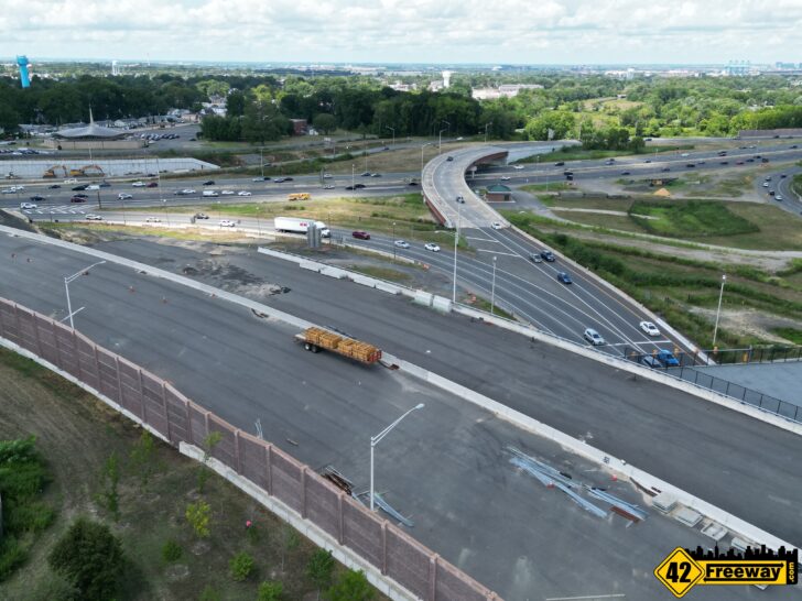
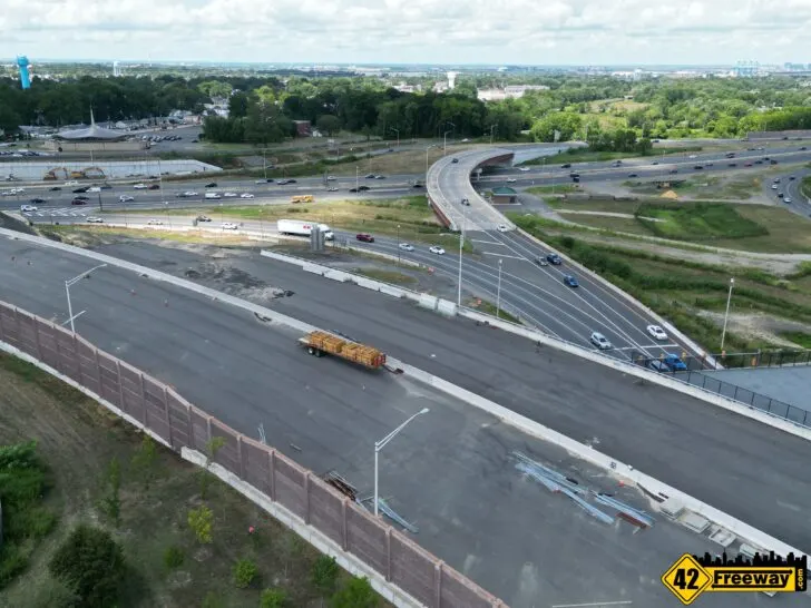
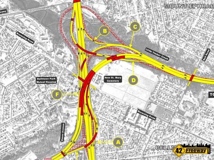
Direct Connection – Up and Over
Probably the number one goal of the Direct Connection project is to get rid of Al-Jo’s curve and offer commuters a more straightened roadway path.
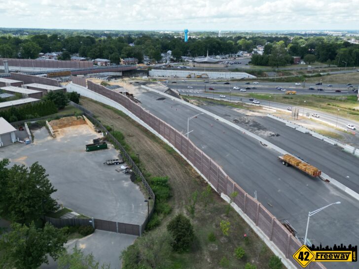
A challenge for this area is that a large cemetery and significant residential housing line surround the roadway area.
While it would be awesome to just build a very direct and straight roadway to connect the two segments of Route 295, it was simply unfeasible.
So the most direct path that could be defined still has a curve too it.. but it’s a significantly smoother and more gentle a curved roadway spread out over a mile through the project core.
Highway speeds are expected to be maintained through the entire new roadway.

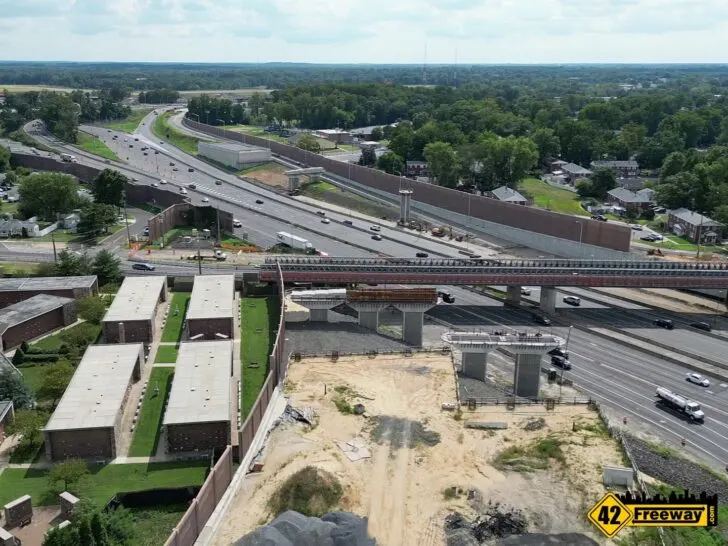
The other challenge is the overall limited area available for all of the necessary highways and local roads in that somewhat small area.
With Route 295 being the principal road in the Direct Connection project, designers wanted it to be least impacted by interactions with other roads.
So they went up and over with it!
The new direct connection roadway will have a gentler slope up to a level segment of roads which will travel over top of all the other traffic movements… including the local Browning Road!
The Name “Al-Jo’s Curve”
Just as a “Fun Fact” that is also relative, the curve gets its name from a Mt Ephraim bar that used to be located right at the apex of the curve.
Al-Jo’s Bar.
The bar was not accessible from the highway of course, but it sat just on on the other side of the concrete barrier of 295 South. Access to the bar was from the local Kings Highway road.
Being a converted older home and sitting higher than the curved roadway next to it, the top of the bar could be seen from Route 295.
And decades ago the owners added a very tall sign proudly proclaiming the building as “Al-Jo’s”

The bar name transferred to the curve as traffic problems and accidents would regularly happen on the curve.
Philadelphia traffic reporters in helicopters would fly to the scene to give the birds-eye view of the roadway issue at the curve.. and there was that Al-Jo’s sign directly next to it.
Al-Jo’s Curve was christened.
The Bowl
Top reason number two is what I call “The Bowl”.
There are two aspects which define this as a bowl.
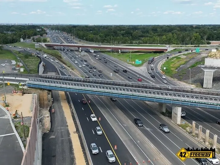
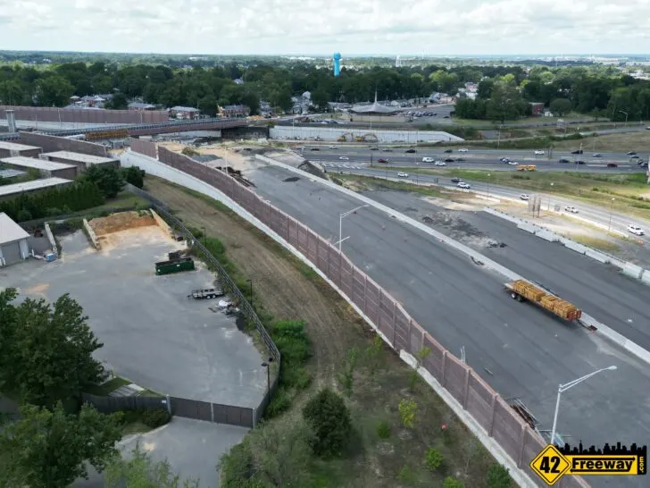
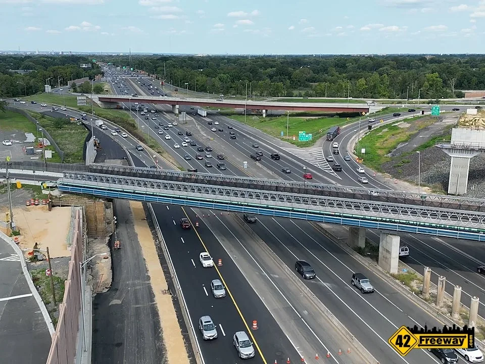
In today’s 295/42/76 roadway interchange it was fit into the existing community by digging well below local surface levels. Twelve lanes of parallel roadways cutting through the center of Bellmawr.
In a way, placing the roads below the surface level did provide some benefits to area residents as it created a sound barrier for much of the traffic noise.
The lower roadways also provided a more level highway through the area as it moved past Bellmawr where the ground is not as high.
So in that regard its somewhat “bowl-like” design is not necessarily a completely bad thing.

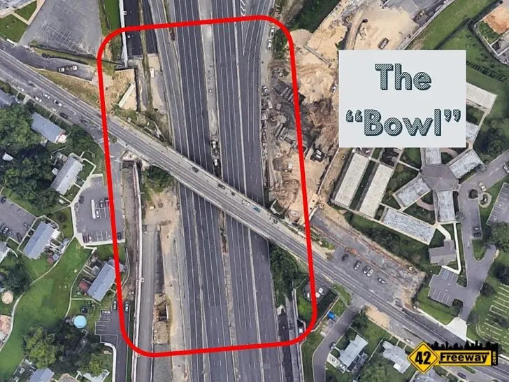
But the other facet is the twelve lanes of roadway.
Basically having multiple traffic movements between several roads, all dumped into a common passageway can be problematic.
In many of the traffic movements that drivers need to make, they have to navigate around other commuters who are going to different places!
“We’re on this road together and I need to get over there where you are, and you need to get over here where I am!”
It reminds me of when the bell would ring between classes at Triton High, and kids would leave classrooms and enter the same common hallway… with each student having a different destination in mind.
Chaos typically ensued.
Just like driving the 295/42/76 interchange today.

Distinct Paths for Commuters. If Only a Cloverleaf would fit…
Consider a widely used pattern in highway construction. The Cloverleaf.
Two highways cross each other and and the distinctive aspect when looking at the interchange overhead are the 4 looping roads bringing the two highways together.
Now I am not saying it is a perfect solution or it’s always a good match for a roadway interchange, but the fundamental things it is trying to achieve are on point.
So take an interchange where two large highways cross each other in a “plus sign” pattern.
One road travels North and South. The other heads East and West.
Vehicles approaching from 4 directions. And they want to be able to travel to any of the three available directions. 12 traffic movements in total.
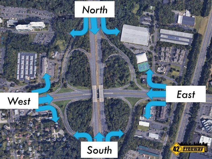

A cloverleaf handles this problem by providing direct individual roadways for each of the 12 movements.
The true beauty of it is for the directional movements from a given direction, are carbon-copies of each other… basically quadruple-symmetry. (Did I just make up that term?)
And once you follow the signs to your destination, everyone else on that same passageway is going to the same direction.
There is no lane shifting. No weaving.
And traffic can just flow.
So I mention this more so just to present a more perfect scenario. The Direct Connection project area is far from perfect.
But the designers of the Billion Dollar plus project have the same goal.
To provide fast travel through the interchange while supporting growing volumes, they want to look at each of the 12 directional movements and make sure each one has a well defined path for commuters. Well as best they can.

A commuter approaches the area, sees a directional sign to where they want to go… and the roadway just takes them directly to that direction on the other side of the project area.
And that’s why my video has 25 minutes of commentary explaining the project. For Direct Connection (and Missing Moves) each of those 12 possible paths are completely unique. Wildly unique.
There will be two tunnels, “cattle-chutes”, express lanes, 4 levels of roadways, multiple ramps.
It’s not that the engineers wanted to do this in a more complex way.
It’s basically a necessity because 100 years of Bellmawr and Mt Ephraim has developed around the project area, and the new design has to work within those boundaries.
Missing Moves
The last aspect of this overly long article is the second Bellmawr project… Missing Moves.
Those “12 possible movements” that I keep mentioning?
Well for 295/76/42 they original project only supported 10 of the 12.
Today you can not travel from 42 North directly to 295 South.
And similarly, you can not travel from 295 North to 42 South,
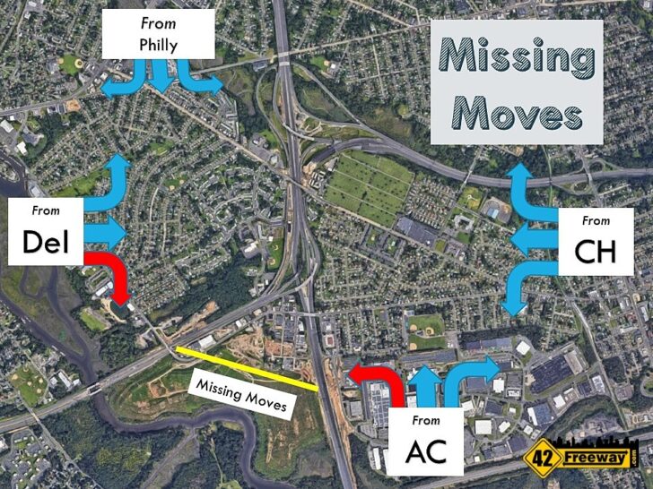

They were just never accounted for. They were missing movements.
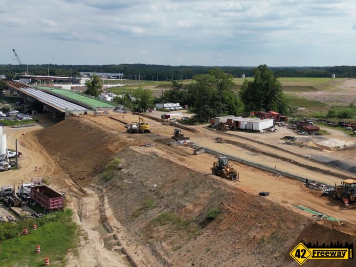
The Missing Moves project started about 2 years ago and is seeing significant progress!
A new roadway is being developed along the edge of the Bellmawr landfill to connect Routes 42 and 295.
The same week as this article I put up an update article and video… for more details, check them out!
But simply the Missing Moves project will make the interchange “whole” and will be completed long before the larger Direct Connection project.
Missing Moves is expected to be completed in late 2023, the last I heard.

Direct Connection Explainer Video
Embedded video below or click this link to view in YouTube page