

The Bellmawr Missing moves project is moving along quite fast, and we have a new YouTube explainer video to showcase the project, as well as answer some questions I’ve seen from followers.
While Missing Moves is the core of the video, I do cover a few other facets of Bellmawr Construction projects.
In this web article I will highlight some of the key questions people have asked, but to get all the details.. check out the video!
First, there is a NEW road project for Bellmawr coming soon, which I see as more of an addendum to the Missing Moves project. NJDOT will be doing a virtual presentation session and ask for commuter feedback.

Also I chat about the Direct Connection project and have some photos at the end of the presentation… but we still don’t have an answer on the roadway collapse.
I also cover one of the most controversial aspects of all the Bellmawr area projects…. “Why do they have traffic lights on the roadway?!”
And of course I do a lot of rambling!
The video is at the bottom of the post (or link here) but I’ll highlight aspects of the video here in this web post.
About Missing Moves
Missing moves is a $180 million dollar road project in Bellmawr New Jersey to allow access direct access from Route 42 to the Southern sections of Route 295.
Currently travelers cannot drive directly on highways to travel across these roads to the south segments of 295, and cars must leave the highways and travel the local roadways to get to their destination.
Currently this adds a significant amount of time to traveling and increases traffic on local roadways.
The “Missing Moves” project will run along the edge of the Bellmawr landfills and connect Route 42 to the South portions of Route 295 in New Jersey.

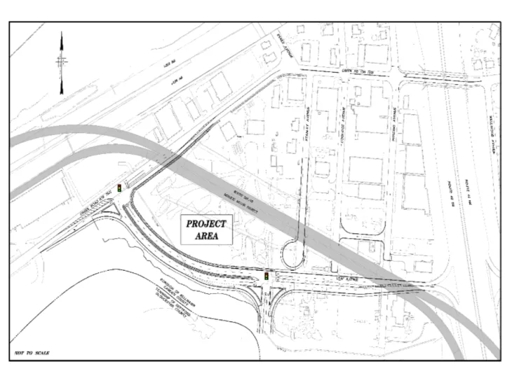
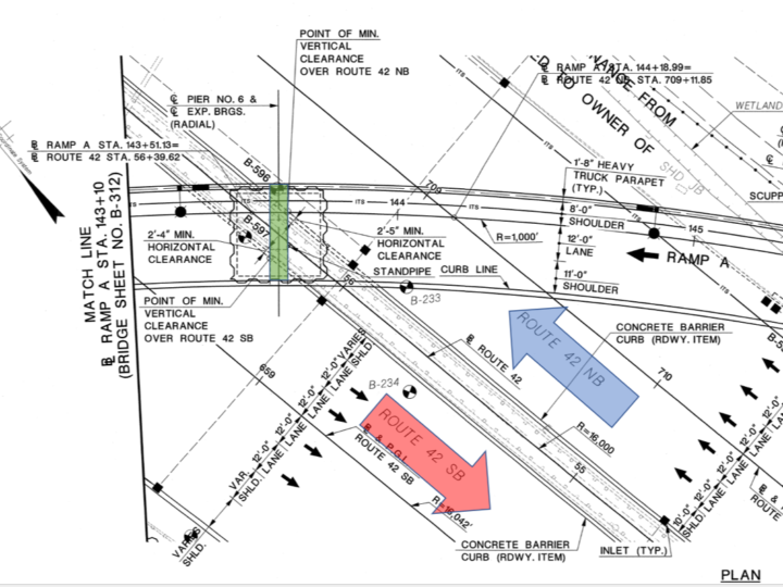
Leaf Avenue Extension – Virtual Public Information Center
The NJDOT will be conducting a Virtual Public Information Center to provide local residents, officials, businesses and the general public with information on the Route 42 Southbound, Leaf Avenue Extension to Creek Road Project.
The NJDOT Project PDF is online (PDF)
Considering the ongoing Covid Emergency status, they are conducting this virtually.
For a period of 2 weeks the project information will be available at the Dewberry Engineering site. After reviewing the information you will be able to submit feedback.
The link is here, but they will not make the content available until June 1st, 2022, and it will be online through June 15th
We’ll see how this goes, but honestly it seems like a better plan for these public sessions regardless of pandemic status! This will definitely be accessible to more people.
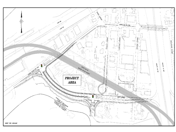
The PDF mentioned above has the NJDOT summary explanation of need and the propose solution.
The 42Freeway spin is…
Currently to get to Route 42 South from the Bellmawr local roads, you have to travel down Harding Ave through the small industrial area.
There is a traffic signal at Creek Road and Harding.
The immediate area around this traffic signal has a lot of things going on… Essex Ave is close, the newer Cura-leaf facility is very close (and draws a lot of traffic).
On the other side of the bridge on Creek Road is a busy Wawa convenience store, and two access roads on either side.. with another traffic signal.
So back to that Harding Ave traffic signal, with all of these roadways interconnected so closely, and the number of vehicles trying to access Route 42 South… things just jam up.
Particularly the traffic backs up West-bound on Creek road ahead of the left-turn into Harding. This backs up down Creek Road and impacts the Edgewood traffic signal.
NJDOT would like to alleviate congestion in this area and make the traffic patterns flow better…
… so the entrance to 42 South from Bellmawr is proposed to be moved a 1/4 mile west on Creek Road, far enough away from the current congested area of Harding… to make traffic flow better.

So a new local roadway will be built off of Creek Road just west of that new overhead bridge, and run alongside the edge of the landfill and lead directly to 42 Southbound.
This placement on the straight stretch of Creek Road will also give additional room for cars to wait at the traffic signal, without impacting other intersection. For those making a left, the Essex Ave roadway is a pretty good distance away.
The only other access in and out of the proposed Leaf Avenue Extension would be a signal in the middle of the extension, for an access road into the Landfill area… in case something eventually is built there.
So a significant takeaway on all of this is… the three streets off of Creek Road which can today eventually get you to 42 South (Harding, Coolidge, Stanley) seem to no longer be access points to 42 South.
You’re only going to be in that small light industrial area if you have a specific purpose with one of those businesses.
Missing Moves – Key Updates
In this post I’ll highlight a few key things of the project… many driven from reader questions.
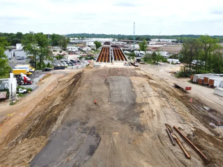
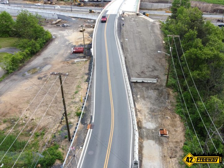
Quick photo rundown.
For more details be sure to watch the video at the bottom of the post.
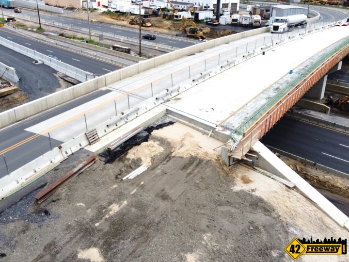
Why was there a gully at the start of Missing Moves roadway of 42 North?
Several months ago the entrance area to Missing Moves off of 42 North was dug down somewhat deep as a valley. Readers speculated if the roadway would dip also, or if it was to be an access road.
Simply, they had to dig deeper to put in a solid foundation for the flat roadway and retaining wall.

For Bellmawr local access to 42 North, can you explain the changes there?
A two-part answer
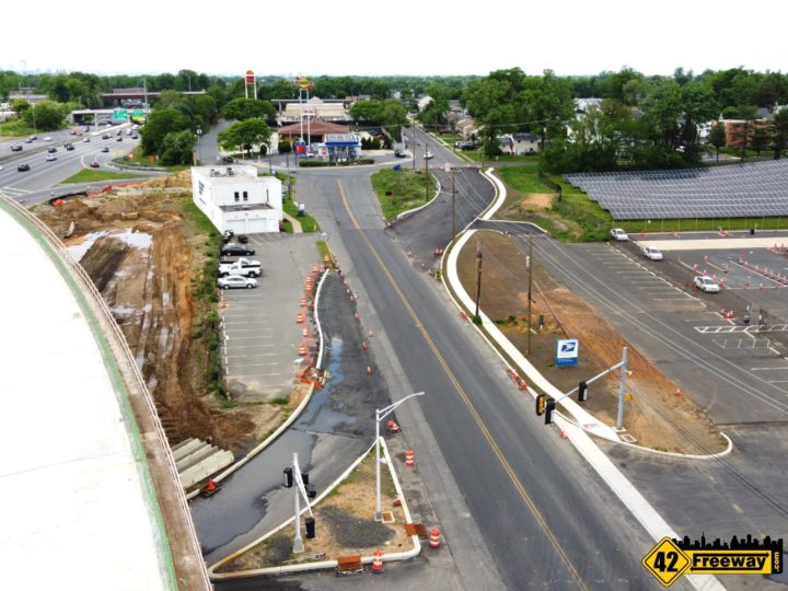
Currently the 42 North exit dumps right into a confusing mix of 5 roadways (in front of the Sunoco).
This makes traveling in this area dangerous, especially as cars coming off of 42 do not have a lot of ramp-room and are dumped right into the mix.
The new plan is to move the exit further South approximately 2 football fields in length.
This moves the exit away from the confusing convergence of roads at the Sunoco, adds a traffic signal, and gives more exit roadway for cars leaving 42 North
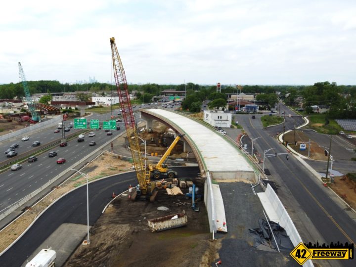

The part II of this is, the changes at Benigno… and what becomes of the current exit?
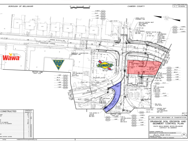
In the image below you can see where Benigno meets Leaf Ave (Sunoco area) there is a new offshoot to the right.
This will be the new route of Benigno. The old roadway will be closed.
The final facet of this is…
well as mentioned the old Benigno starting point at Leaf will be closed (as indicated by the red highlight below)
The old entrance on to 42 North tho will still have some life left in it, as it will still be available for State Police use (there is a Barracks there). I indicate that in purple, in the image below.

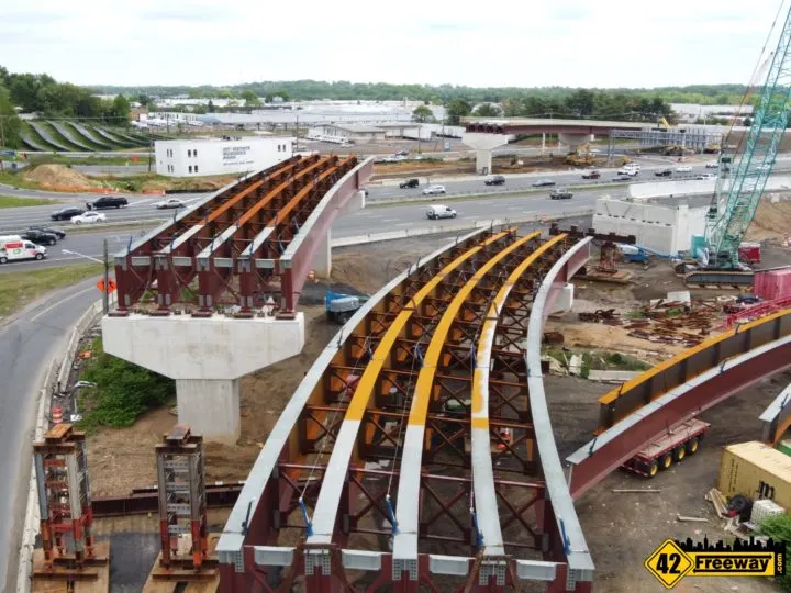
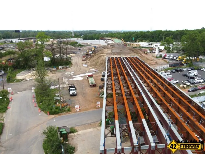
For the bridge over Route 42, will it have a center pier or are they spanning all the way across?
The steel for the roadway decking on either side of Route 42 is fairly close to the roadway, leading people to wonder if they were going to span across Route 42 without a support pier.
Yes, there will be a support pier.
We reviewed the design documents and see that “Pier 6” is panned for the thin center median.

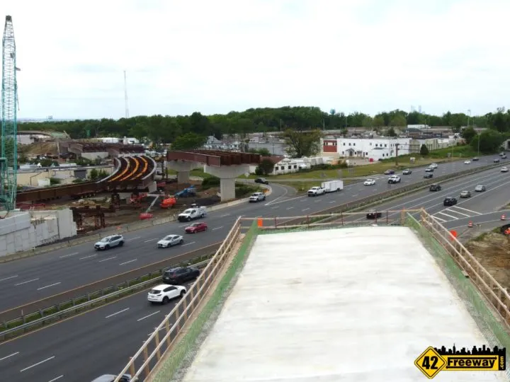
It may seem odd that no construction has happened yet on this pier, but our theory is they want to finish the exits and roadway on either side of Route 42 before they start the pier, so they have room to shift traffic over.
While it seems the new center pier will fit nicely in the current tight median, it’s going to take trucks and workers to build it…. which means eventually those interior lanes will have road closures.
And I’d imagine lanes will shift over to the outer sides of the roadway.
So I don’t know the timing of this segment of development, but will ask the NJDOT media team. They way steel is going up for the project it makes me wonder if it’s sooner rather than later.

Will Missing Moves traffic have access to the local Bellmawr Roads?
No, the Missing Moves roadway will not have access to the local (Bellmawr) roads.
This actually was a request of the town and the developer of the landfill many years ago.
It was stated that for a large development to happen in the landfill (such as the long ago rumored Bass Pro Shops), direct access from 295 into the landfill was needed.
While NJDOT did not accommodate this request, there is a segment of the Missing Moves roadway which will be a raised dirt hill.
First and foremost I imagine this was done as a cost savings measure, as there really was no need to make this section a raised steel roadbed.
But the extra advantage is… maybe if things change and exits off of the Missing Moves roadway are determined to be needed, this stretch of dirt supported roadway could make for a great place to add it.

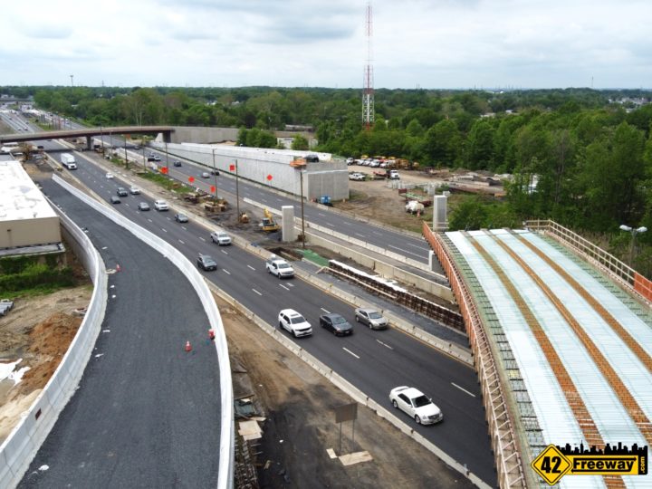
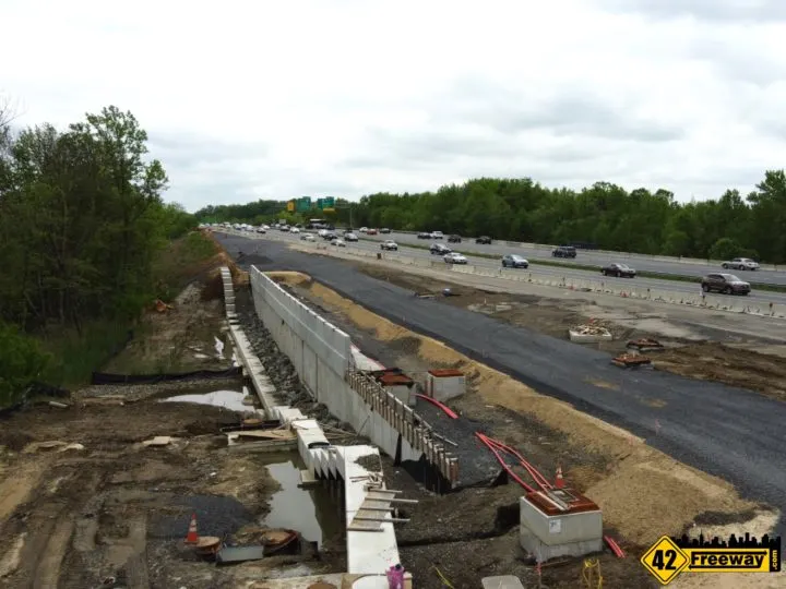
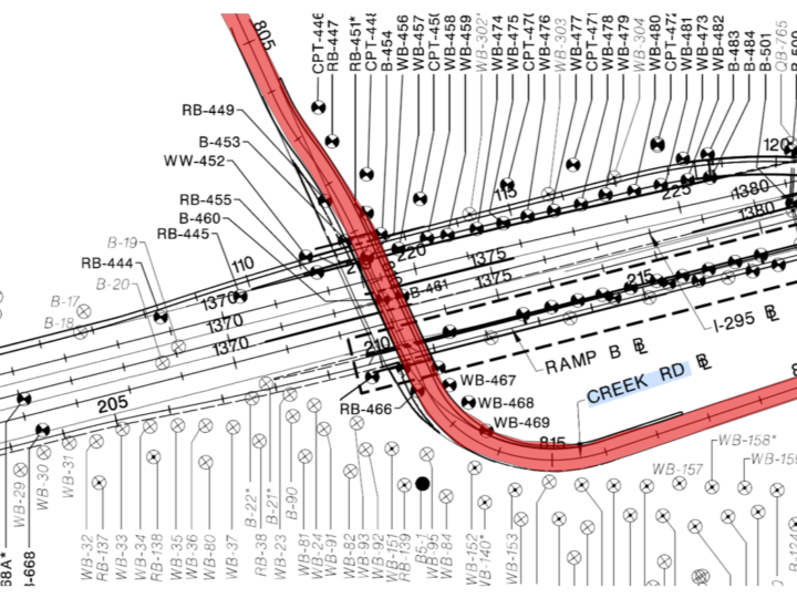
Can you explain the new Creek Road Bridge? It’s currently narrow and curved!
The new Creek Road bridge over 295 is only half completed.
The current roadway is narrow because both direction of traffic are on half of the bridge, as the other half is completed.
Once it is all completed, the bridge will be much wider than the old bridge, and easier to navigate.

On the Bellmawr Lake side of the bridge, the roadway has a bend.
Yes this is permanent and part of the final design.
Currently this feels tight because only half of the bridge is being used.
Once completed and the full roadway is available, the bridge will have a curve on North side, to align it back with Creek road.
To fit in the new bridge build, connect it to the existing Creek Road, and keep traffic flowing… NJDOT implemented a plan to shift the new bridge over basically one lane… rebuilding and demolishing the bridge, one lane at a time.

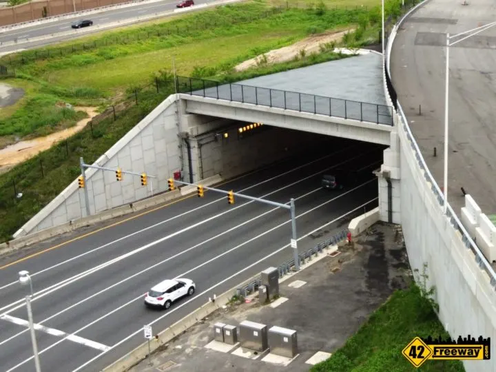
Why are there traffic lights at the start of the tunnel in the 295 Direct Connection segment?!
Safety reasons if there are any issues within the tunnel, such as a disabled vehicle or roadwork.
It seems to be standard-issue for all New Jersey tunnels, as they are also in place for the Route 29 tunnel, and the Atlantic City tunnel (to the Marina district Casinos)
At the end of the video I show those examples.

YouTube Video
Embedded below or here is a direct link